DEFINITION:
Surveying is the science and art of making all essential measurements to determine the relative position of points or physical and cultural details above, on, or beneath the surface of the Earth, and to depict them in a usable form, or to establish the position of points or details.
OBJECTIVE OF SURVEYING:
- The aim of surveying is to prepare a map to show the relative positions of the objects on the surface of the earth.
- To collect field data.
- To prepare plan or map of the area surveyed.
- To analyze and calculate the field parameters for setting out operation of actual engineering works .
- To set out the field parameters at the site for further engineering works.
GENERAL PRINCIPLE OF SURVEYING:
The general principles of surveying are:
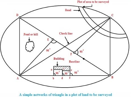
- To work from the whole to the part
- To locate a new station by at least two measurements (linear or angular) from fixed reference points.
The purpose of working from whole to part is “to localise the errors and to control the accumulation of errors”.
According to the first principle, the whole survey area is first enclosed by main stations and main survey lines. The area is then divided into a number of divisions by forming well conditioned triangles.
USES OF SURVEYING:
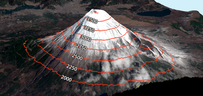
- For preparing the contour map to determine the best possible route and amount of earthwork required.

contour map - For preparing the engineering map showing engineering details like highways, railways, canals, dams, reservoirs, etc.

engineering map - Maps prepared for marking boundaries of countries, states, districts etc., avoid disputes.

boundaries of countries - For preparing the topographical map which shows hills, rivers, forests, valleys, etc.

topographical map - For planning and estimating project works like roads, bridges, railways, airports, water supply and waste water disposal surveying is required.
- Marine and hydro-graphic survey helps in planning navigation routes and harbours.
- For preparing a military map showing different strategic points important for the defence of a country.

military map - Mine surveys are required for exploring mineral wealth.
- For preparing archaeological map showing the places where ancient relics may have lied.

archaeological map - Astronomical survey helps in the study of movements of planets and for calculating local and standard times.
Subscribe & Watch Technical video’s related to civil engineering on our YouTube channel We Civil Engineers


thanks for your best explanation about surveying and its principle